INVESTIGATIONS
A drone fell on a crowded civilian street in Sanaa
August 18, 2023A drone reportedly fell onto a crowded commercial street in Amanat Al-Asimah Governorate.
Print Article
Incident Summary
- Incident: A drone fell on a crowded civilian street in Sanaa
- Location: Near Al-Rowaishan Roundabout, in front of Yemen Commercial Mall, in Al-Wahda District of Amanat Al-Asimah Governorate
- Date: 23 May 2022
- Time: between 20:50 and 20:54
- Casualties: three civilians dead and three others wounded including women
- Potential drone type and operator: A Chinese-designed CH-4B UAV, possibly operated by Saudi Arabia forces.
Introduction
On the evening of 23 May 2022, while the UN truce was in place, a drone reportedly fell onto a crowded commercial street near Al-Rowaishan roundabout, in Al-Wahda district of in Amanat Al-Asimah Governorate, killing and injuring civilians, and damaging civilian property. Claims varied about who was responsible for shooting the drone down and why it fell, as well as for who was responsible for launching it.
About the area
According to the Open Street Map, Al-Ruwaishan roundabout is located at the intersection of Haddah Street with Al-Quds Street and Al-Dairi Road, in Al-Wahda Directorate of Amanat Al-Asimah Governorate, which is under the control of the Houthi “Ansar Allah” forces. The area has restaurants, shops, and malls that are crowded throughout the day. The intersection is one of the main crowded areas with cars and public transport buses.
The crashed UAV is situated in the Al-Ruwaishan area, approximately 433 meters away from the nearest non-civilian site, which happens to be the central command headquarters of the Central Security Forces. The area includes buildings and warehouses, as well as the police hospital, which was previously attacked by the Saudi-led Coalition forces several times, most recently on 23 December 2021.

A screenshot from Open Street Map Showing The distance between the impact site and the location of Central Security Forces.Taken by the Yemeni Archive in February 2023.

Image from Google Earth pro of the Central Security location, showing its distance from the drone crash site. Taken by the Yemeni Archive in February 2023.
About the drone crash
Social media users on Twitter and Facebook circulated news about hearing an explosion in the capital of Sana’a. These include reports by Osama Abu Monser’s and by Hadi Al-Shami who published reports at 20:54 Sanaa time. One minute later the National Press Association tweeted a statement claiming that the explosion was likely caused by a raid by Saudi-led coalition airforces on Sana’a. One of the comments on Osama’s tweet stated that a “violent sound” was heard at 20:50 local time, which is four minutes before the tweet was posted.

A screenshot of Osama Abu Monser’s tweet at 20:54: “Now #Sanaa. The aggression’s war aircraft are bombing Sanaa.”Taken by the Yemeni Archive in December 2022.

A screenshot of a comment by Eng - Mohammed account at 21:04 on Osama Abu Monser’s tweet: “We all heard the sound, it was violent at exactly 20:50 #Sanaa.”Taken by the Yemeni Archive in December 2022.

A screenshot of Hadi Al-Shami Facebook post at 20:54: “A violent explosion rocks Sanaa… “Taken by the Yemeni Archive in December 2022.

A screenshot of the National Press Association tweet at 20:55: “Urgent: An explosion was heard in the Yemeni capital, Sanaa, believed to be caused by an air strike.”Taken by the Yemeni Archive in December 2022.
Several sources published surveillance video taken by shop cameras allegedly near the drone crash location that had been uploaded to Twitter, Facebook and YouTube. According to the open source information obtained by Yemeni Archive, Hadath in Yemen Facebook page was the first source to publish the surveillance camera video. The time of publication was on 23 May 2022 at 22:41:00 Yemen local time, approximately 1 hour and 30 minutes after the incident occurred.

Screenshot of Hadath in Yemen Facebook page’s post, showing the CCTV video and the time the video was posted on 23 May 2022 at 22:41:00 Yemen local time.
The same video was also published by Al-Sultan al-Yamani’s YouTube channel. The timer of the surveillance camera screen appeared seconds after the first parts of the drone hit the ground, with a wider and clearer snapshot with the date as: Monday 20:51:58. Following this, what appears to be remnants of the aircraft fell, at a time showing 20:52:00. The date on the monitor did not show the day of the month, the month, or the year.

Screenshots from surveillance camera video, in which the time is displayed at 20:51:48 -20:51:49 when the first parts fell. The brightened colored oval shape in the right bottom corner of the photo shows the location where the drone fell.

Surveillance camera footage of the incident shows the time is Mon 20:51:58 seconds after the first parts of the drone hit the ground. Red arrow points at the fallen object. A screenshot from Alsltan Alymani video.

Screenshots from surveillance camera video. A lit rectangle above appears the timer at the top in the two pictures 20:52:00 -20:52:01 during the fall of the second part of the drone marked by the large oval figure in the picture below, meters away from the first falling part marked by the small illuminated circle.
As mentioned earlier, the incident was reported on social media to have occurred on 23 May 2022. The date of the tweets does not show the day of the week.
Looking up which day of the week it was on the date of reporting the incident in social media confirms that 23 May 2022 was a Monday, the same day of the week shown by the surveillance camera footage.
In the surveillance camera footage, an arch-shaped object appears in the top right corner, and six stairs appear at the entrance of the Mall, which corresponds to the facade decoration of Yemen Mall. Additionally, photos of the Mall show surveillance cameras in a position that corresponds to where the footage was taken from.
Photos of Yemen Mall posted by users on Google Maps show the same parking sign, stairs, the Mall facade with arches and the surveillance camera which recorded the incident and whose footage was published by Alsltan Alymani YouTube channel.

Bottom Right:Surveillance camera footage of the incident shows an arch-shaped object and six stairs at the entrance of the Mall. A screenshot from Alsltan Alymani video. Left: Yemen Mall with the stairs and facade arches. Photo published by a user on Google Maps. Top Right: Yemen Mall facade arches and surveillance camera. Photo published by a user on Google Maps, in the middle cropped by Yemeni Archive for a closer view. Red arrows point at facade arches. Green arrow points at a surveillance camera.
At the end of the clip published by Sultan Al-Yamani, the surveillance camera footage showed a side part of an advertising poster on the front of the mall. The same advertisement can be seen in the mall photos taken after the incident occurred, by other internet users, indicating that the photos were taken within a limited time frame.

Left: Surveillance camera footage of the incident shows the side part of an advertisement poster on the Mall facade. A screenshot from Alsltan Alymani video.Right: A photo of Yemen Mall showing the same advertisement poster that its side part appeared in the surveillance camera footage. Photo published by a user on Google Maps, cropped by Yemeni Archive for a closer view. Red arrows point at the advertisement poster.
This might indicate that the footage was taken by a Yemen Mall surveillance camera. It is worth noting that the Ansar Allah Houthi government imposes regulations on shop owners to purchase and install internal and external surveillance cameras and adjust their timing accurately so that the Operations Room of the Ministry of Interior can identify criminal activities in the area in addition to monitoring any possible riots. Other corroborating factors for the time in the video includes that the footage shows evening time, the heavy traffic at this time of the day, and the open Yemen Mall which closes at 10 pm.
By matching the time of the users’ posts on social media with the time in the surveillance camera videos, the time of the alleged drone crash is estimated to be between 20:50 and 20:54 on 23 May 2022.
The location of the impact
Geolocation of open source media related to the incident was conducted by comparing the visual landmarks shown in a video by the Ansar Allah Media Center and Yemen Max news network on YouTube. This resulted in the coordinates of the drone crash to be located near Al-Ruwaishan roundabout in the Al-Wahda District of the capital Sanaa, in front of the Yemen Mall on Al-Dairi Road.
The first fallen object was around 3 meters away from a parking sign in front of Yemen Mall as shown in footage of Sultan Al Yamani. which confirms the impact location of the first parts of the UAV being in front of Yemen Mall gate at coordinates: 15.334864, 44.197466 . While the other part, represented by a part of the structure attached to the wings, fell close to the building in front of the side facade, at coordinates 15.3349817,44.1973898.

Left: Surveillance camera footage shows the object around 3 meters away from the blue parking sign. A screenshot from Alsltan Alymani video. Right: The parking sign in front of Yemen Mall. Photo published by a user on Google Maps, cropped by Yemeni Archive for a closer view.

A comparison showing the location of the drone crash matching through two images from two different angles from two different sources. In a screenshot from Ansar Allah Media Center video, and Yemen Max Network video showing the facade of Yemen Mall building marked in white and the wreckage of the drone in front of it, in addition to some individuals gathered around the wreckage. The color of the building facade, the shape and the number of billboards on it can be seen, all of which are identical.

A comparison showing the location of the drone crash matching through two shots from two different angles from two different sources. In a screenshot from Ansar Allah Media Center video, “the image at the top right” a food cart of a street vendor appears clearly, “the pots, the blue plate of the cart,” in addition to a white taxi next to the drone wreckage, the identical components appear in a screenshot of from Yemen Max Network video from a frontal angle, showing the taxi and the food cart aligned with the wall of the plot next to the drone wreckage.

A screenshot from a video of the Yemen Max News Network channel in the upper right, in the lower left of the video of the Al Modareb Muhammad Hadi channel, and another at the middle right of the video of Ahmad al-Missibli’s tweet, identical and identical to A satellite image from Google Earth Pro of the crash site. Gray: the Yemen Mall building. White: a wall of a neighboring land. Black: middle of the street.
Damage to civilian property
The impacted site seen in the published videos appears to be in an area crowded with traffic. The visual content showed two cars next to the wreckage of the drone which did not show clear signs of damage, and motorcycles under the wreckage of the drone, which may have been damaged as a result of the falling aircraft. Other damages to the shops and shopping center opposite the crash site in the video were unable to be confirmed due to the street lights being turned off after the drone crash.

A screenshot from the War Media video showing motorcycles with the wreckage of the drone.

A screenshot from the War Media video showing motorcycles with the wreckage of the drone.
Victims
Based on available open source information, the incident resulted in the killing and injury of multiple civilians. Official sources, including Saba Agency, Al-Masirah, and Euronews, claim the incident resulted in the death of three civilians and the injury of three others, one of whom was in critical condition.
Hani Ahmed’s account tweeted on 24 May 2022 at 00:41, hours after the incident occurred, mentioning the killing of “Abdul Qawi Ali Mohsen Al-Ja’dabi ” as a result of a UAV crash in Al-Rowaishan. Another video published by the Yemeni Network for Rights and Freedoms showed one of the civilians allegedly killed as a result of drone wreckage falling on him.
A tweet for the ”Al-Mahreya TV Channel” account mentioned the death of the Syrian youth, Ammar Ahmed Al-Jarrah, in the incident, adding that there is no certain fate for his body, and attached a picture of him and a copy of his passport as well. It is worth noting that the passport states that he was born in 1976, at the age of 45, when he was killed in the accident.
Lastly, the Ministry of Health of the Houthi government published an update on May 24, 2022, through a statement on the ”Ansar Allah” news website, the names and ages of the killed and injured in the UAV crash, including three females and a young man of Syrian nationality in the Al-Ruwaishan area, attached as follows:
Killed:
1- Abdul-Qawi Ali Muhsin Al-Ja’dabi – 23 years old
2- Ahmed Shawqi Abdul Rahman Qaid Al-Hajj - 18 years old
3- Ammar Al-Garah - Syrian nationality - 35 years old (whose age estimate differs from 45 years old which is written in his passport)
Injured:
1- Reham Abdullah Al-Jaar (17 years old- Female ), who was wounded in the lower lip.
2- Samiha Ahmed Hamran (30 years old- Female), who was hit in the back of the head.
3- Rawan Abdullah Al-Jaar (16 years old- Female), who was hit in the right shoulder
Claims about the reason the drone fell and whom it belongs to
Minutes after the crash of the drone, Brigadier General Yahya Saree, an official spokesman for the Houthi forces, tweeted that the air defenses had shot down the drone with a locally-made surface-to-air missile, claiming that the drone was a Chinese-made CH4 spy drone owned and operated by the Saudi Air Force.

Zafaran Zaid, a member of the advisory body of the Yemeni Ministry of Human Rights, tweeted a claim that the Ansar Allah Houthi had failed to launch a drone, and that the drone fell. The same claim was shared by the Yemen Shabab website. Rabih al-Qurashi, a military spokesman for the Yemeni army forces in the sixth military region of the internationally recognized government, claimed that the drone that fell on civilians was a Houthi spy drone launched from Jabal al-Nahdain in the capital. A Chinese website claimed that according to news published by Saudi social media users, the drone fell due to the fault of the drone operator, and that there was no problem with the drone itself. Yemeni Archive was unable to find an official statement by the Saudi-led coalition about shooting down this drone or the cause of its fall.
About the drone
A video by the Yemeni Military Media Channel posted to YouTube showed close-ups of the remains of the UAV that the Houthis claimed was a Chinese-made CH4.
The UAV’s wreck shows it was equipped with one backwards-mounted (pusher) propeller, two main wings and retractable landing gear. Further, the significant size and weight of the crushed UAV – its impact killed and wounded six people without a detonation occurring – and its general design identify it as a medium-altitude, long-endurance unmanned aircraft system (MALE).
The dimensions of the crushed UAV can be estimated using the white car that was near the wreckage of the UAV as a reference object. The car seems to be a five-door Toyota Corolla of the tenth generation (E140), which is very popular in Yemen. This family of cars is roughly 4.5 m long, 1.7m wide and 1.5m tall.

Top: a sample of a Toyota Corolla. bottom a Toyota Corolla that was at the incident location near the wreckage.
Thus, one wing of the crushed UAV wings appears to be at least 6.5m long, with the fuselage being roughly 800mm wide. This would result in a wingspan of at least 13.75m – likely longer as both wing tips were damaged in the crash and are hardly visible.

Measurements were taken relative to the length of the car. Note the selected part of the image has been brightened. A screenshot taken from the war media video.
Images of the wreckage show that the crashed UAV was equipped with a wheeled landing gear with straight legs. The landing gear could be folded into the fuselage. Such a landing gear setup is featured on several UAVs of larger size and generally folds backwards to be stowed away. As the landing gear is facing upwards, it is clear that the UAV is lying upside down.

A screenshot taken from the war media video showing the landing gear “wheels mounted on straight legs” folded into the fuselage, confirming that the UAV is lying upside down.
Further, the relatively flat underside, the low-mounted wings of the UAV’s fuselage, and the distinctive curve where the wing meets the fuselage stand out.

Left: Side view of the UAV from the war media video, showing its relatively flat underside and low-mounted wings. Right: A photo from the Ansar Allah Media Center. A circle has been placed at the attachment of the wing to the fuselage.
The crushed UAV Components
After examining a set of close-up shots taken of the wreckage, a number of identifiable internal components of the crashed UAV can be revealed.
Engine
Characteristics of the engine appear consistent with those of a 915 iS four-stroke piston engine produced by the Austrian company BRP-Rotax GmbH. These include the three distinct blue cover plates which appeared in one of the photos shared by the Ansar Allah Media Center as well as a label on the engine with “915 iS”. This engine is designed for civilian propeller aircraft and provides between 135 and 141 horsepower (depending on the exact configuration) allowing for a maximum operating altitude of 23.000ft (~7.000m).

Top Right: Pictures taken from the Media Center of Ansar Allah .Bottom left:Pictures taken from the Military Media of the crashed UAV’s engine that fell in Sana’a, showing the symbol 915iS, which is the type of engine model from the ROTAX company, moreover the three distinct blue cover plates placed on the engine can be seen. Bottom right and top left: two pictures of the engine from the website of the ROTAX company showing corresponding information and characteristics.

Screenshots from a video published by Yemeni Network for Rights and Freedoms showing at the top “the rear part of the drone” a piece of a broken rear wing with the engine of the drone appearing to be stuck between fallen wreckage. At the bottom, screenshots from Yemeni Military Media video showing the engine with “ROTAX” written on the blue piece, the name of an engine manufacturer, attached to the same wreckage found at the crash site.
Strobe Power Supply Unit
The crushed UAV appears to have been equipped with a strobe light system to increase the UAV’s visibility. Such a light system requires a dedicated power unit which can be observed in the military media video. The adhesive and writing on the power unit indicate that it may have been produced , by the American company Whelen Engineering Company. This dedicated unit seemingly provided 28V DC at 2A, with a manufacture date of August or May 2020 and model HDS1428, according to the manufacturer’s catalogue.

Left: an image from the military media video showing a WHELEN power supply unit, MFG date, supply size, and model. Top Right: a photo from the manufacturer’s catalog. Bottom Right : a similar model from ebay shop website for the same model of power supplies.
Other Components
Several other components are shown with their markings, albeit no positive identification can be made as of the time of writing.
The UAV was equipped with a Ku-Band Transponder, which transmits information in the 12 - 18 gigahertz radio-frequency spectrum. The component is equipped with visible markings reading ‘TM314-100-‘ with ‘TM’ believed to stand for Transmission Module, plus the date 30 June 2020 which might be the production date. At present, it is unknown who manufactured this component.

A screenshot from the war media video showing the Ku-Band Transponder, with information as TM314-100. “TM” is believed to stand for Transmission Module, and the date 6/30/2020 may be the production date.
Besides the KU-Band transmission module, the UAV’s actuator controller and radar altimeter data plates are also visible. Based on these, the UAV was equipped with an actuator capable of exerting 30 newton-meter of torque.
Additionally, the UAV was equipped with a radar altimeter. A radar altimeter measures the altitude of the UAV by timing how long it takes a beam of radio waves to travel to the ground, reflect, and return to the craft. Notably, there appear to be Chinese characters printed on the actual altimeter and then covered by the data plate label.

Screenshots taken from the war media video, when Scanning the QR code yields the same information as printed on the labels. Top: a data sheet label for a drone operator control unit capable of exerting 30 Nm of torque. Bottom: a radar altimeter data sheet label showing some letters. Chinese characters were printed onto the actual altimeter and then covered by the data plate label.
Notably, both data plates for the radar altimeter and the actuator controller list an NSN. NSN is generally understood to refer to NATO Stock Number. The NATO Stock Number is a 13-digit numeric code used by the NATO military alliance, identifying all the “standardized material items of supply” as they have been recognized by all member states of NATO. The NATO Stock Number has come to be used in all treaty countries, with some non-member nations also having adopted the NATO Stock Number system (e.g., Japan, Australia and New Zealand).
However, the NATO Stock Number structure is strictly regulated and stipulated to consist of 13 digits with only a two-digit Material Management Aggregation Code suffix to be appended when the asset end use may be denoted. Thus, the NSN listed on the crushed UAV is inconsistent with any NATO Stock Number as it consists of 12 digits and one letter.

A sample image showing the build of the 13-digit NATO Stock Number

Top: a scanned image of the QR of the crashed UAV’s operator control unit data plate label. Bottom: a QR scanned image of the crashed UAV’s radar altimeter data plate label. They show a 12-digit, one-letter NSN code, which does not correspond to any NATO Stock Number.
Based on photos published online it can be observed that the crashed UAV’s radar altimeter transmitter and receiver antenna were mounted on the underside of the UAV next to the landing gear bay. In addition, a blade antenna is mounted between the two, which is assumed to be a UHF data link or a transponder.
Notably, the radar altimeter transmitter and receiver antenna on American or NATO aircraft would be equipped with a radiation hazard placard, which is missing on the crashed UAV.

A screenshot from the Military Media video showing the marks on the wrecked fuselage of the UAV. Note the white components are the radar altimeter transmit and receive antenna. An American/NATO aircraft would have radiation hazard placards here. In between the white components is a blade antenna that may be assumed to be a UHF data link or transponder.
A data plate related to the UAV’s camera and camera gimbal is also visible. The name “EOIR” is believed to refer to EO/IR (Electro-Optical/Infra-Red) cameras. Such systems are imaging systems spanning both visible and infrared wavelengths, providing visual images to the operator day and night and in low light conditions. The camera system setup documented in the UAV’s wreckage appears consistent with an EO/IR setup. The date “December 2020” was also attached to the plate, which may refer to be the date of EO/IR system setup.

Screenshot from the war media video showing the crashed UAV’s camera and gimbal system data plate. The data plate reads: Name: EOIR, PN:RVGD 450, SN:202016, Date: 202012.
Lastly, a cased unit is visible, which is most likely a controller unit of an unknown model. The data plate indicates that the unit runs on 28 volts. TTL refers to a serial data port. There appear to be three power buses at 7V (which is unusual), 5V, and 12V. Thus, it is assume this is a power control unit of a currently unknown function.

Screenshot from the war media video showing a cased unit is visible , has data indicating that it operates on 28 volts. TTL stands for Serial Data Port, and the three electrical buses are 7V, 5V, and 12V.
Identifying the UAV
External Features
By analyzing the remains of the crashed UAV, its size stands out. Based on the general context and the geopolitical situation there are only a handful of such UAVs that have been observed operating over Yemen. Such as UAVs belonging to the Saudi, Emirati and Iranian(which support the Houthis) air forces .
The extensive damage to the UAV made it difficult to determine the physical features. However, the crashed UAV was relatively large, featuring a retractable wheeled landing gear, a flat-bottomed fuselage, and a distinctive curved section where the wing meets the UAV’s body. These physical features seem broadly similar to MQ-1 Predator-like drones, including the American-made MQ-1, the Chinese-made Chang Hong-4 and the Iranian-made Shahed-129, Shahed 149 and Kaman 22.

Comparison of UAVs similar to the MQ-1. Top Left: A Chinese CH-4B. Top Right:An Iranian Kaman 22. Bottom Left: An American MQ-1B. Bottom Right:An Iranian Shahid 129 believed to be in its newer configuration.
The external features of the UAV allow for an identification of the model. The drone featured a low-mounted wing set, a feature consistent with the MQ-1 Predator and the CH- 4. However, low-mounted wings rule out the Shahed-129, which features high-mounted wings. Further, the overall size and fuselage design are inconsistent with the Shahed-149. In addition, the Kaman 22 also features a broader chord at the root of the wing – thus being inconsistent with the wreckage of fallen UAV.

Comparison of wings attached to UAVs. Top Right: wrecked UAV’s wing attachment the low-mounted. Bottom Right: MQ-1B UAV. Top Left: CH-4B UAV “possible match”. Bottom Left: Shahed-129 UAV. Bottom Middle: Kaman 22 UAV “Not Match”.
When examining the landing gear by shape, it appears inconsistent with the American-made MQ-1 Predator. Specifically, the hinge point of the landing gear is further back on the MQ-1 compared to the wreck in Al-Ruwaishan. This feature is, however, consistent with the CH-4.

Comparison of landing gear bays. Right:An American MQ-1. Middle: the crashed UAV . Lift: a Chinese CH-4 at the Zhuhai Airshow.
Internal Features
It stands out that all documented markings on the UAV that crashed in Sanaa were written in English. Secondly, all components that could be identified were of Western production – specifically, the Austrian-made engine and the American-made strobe power supply unit.
However, Rotax aviation engines are widely used in MALE and similar-sized UAVs. Specifically, the MQ-1 Predator reportedly uses a Rotax 914F with 115 hp, the Heron MK II uses the Rotax 916 iS engine (which is no longer offered on the company’s website).
The Shahed-129 is also widely reported to use a Rotax 914 four-cylinder engine, and Rotax 912 engines were documented in Mohajer-6 UAVs in both Ukraine and Iraq. On the other hand, it is expected that CH-4s manufactured in China would be equipped with Chinese components and not rely heavily on Western components. Nevertheless,Oryx had documented other CH-4s that crashed in Yemen were also using Rotax engines.
Specifically, a CH-4 crashed in January 2020 in the Yemeni province of Al-Jawf as it was equipped with a Rotax 914 UL/F engine. The engine appeared in video footage published by Al-Bass Al-Yamini and photos published by Yemeni Press. Moreover, in December 2021 and February 2022 the crashes of two CH-4s with a Rotax 915 iS engine which is identical to the engine in the crashed UAV were also documented.

Left: images of the UAV’s engine that crashed in January 2020. Right: A 3D rendering of a Rotax 914 UL / F four-stroke piston engine from the manufacturer’s website.

Right: a picture of the engine of a Rotax 915 iS CH-4 that crashed in the Yemeni city of Haradh in February 2022. Left: a picture of the engine of a Rotax 915 iS CH-4 that crashed in Yemen in December 2021. Bottom Left: a sample Rotax 915 iS engine.
Upon analyzing the wreckage, it stands out that, except for the illegible Chinese writing on the radar altimeter, all visible markings were in English, and major components were of Western manufacture. This seems to contradict the assertion that the CH-4 was manufactured in China, as CASC , the manufacturer of this type of drones,would most likely rely on domestically produced parts. However, CH-4s intended for export could be equipped with Rotax engines According to the Flyer website, the Chinese engine is a copy of the Rotax engine, and according to weapons experts, the customers of the CH-4 are being offered a choice between the Chinese and the Rotax engine. A customer country would then choose the Austrian-made engine as spare parts would be more easily accessible, and the engine’s maintenance would be simplified if the engine was made in Austria.
In conclusion, the UAV that crashed in the Al-Ruwaishan roundabout appears consistent with Chinese-designed CH-4 UAVs. Based on the overall size and configuration of the UAV being consistent with the MQ-1 Predator and its derivatives, the Shahed-129 and the CH-4. Of these three UAVs, the low-mounted wings, the landing gear bay shape, and hinge point are only consistent with the CH-4. The markings, style of data plates, and lack of warning labels found on the crashed UAV are inconsistent with those on American/NATO UAVs.
The Chang Hong-4
The China Aerospace Science and Technology Corporation (CASC) produces the CH-series of UAVs that can be described as Predator-type drones – sharing many characteristics with the American- made MQ-1 Predator UAV and its Iranian copy, the Shahed-129. “CH” stands for “彩虹” (cǎihóng) or “rainbow.” TheEurAsianTimes published that the Chinese air force (the PLAAF) operates the CH-4, but according to the Special mission for aircraft and unmanned systems’ book China’s CH-series of UAVs have primarily been exported to South and Southwest Asia, as well as Africa.
The CH-4 comes in two fundamental variants. The reconnaissance CH-4 and the offensive reconnaissance CH-4B. The CH-4A variant cannot be equipped with arms and is only used as a reconnaissance UAV; the CH-4B can be equipped with a selection of precision- guided missiles and bombs. Hence, the CH-4B can be used as both a reconnaissance and a combat UAV. Besides the fundamental variants – CH-4A and B – the CH-4 family of UAVs has undergone several improvements since its maiden flight, either by CASC in China or the UAV’s various operating nations. Thus, depending on its year of production and user, a given CH-4 may feature various improvements or additional capabilities, such as a more capable engine or a satellite communications terminal.
Besides procuring complete CH-4s from CASC in China, some nations also receive technology transfers to local companies; thereby, they may service, upgrade, or even build their CH-4s. Most significantly, Saudi Arabia hosts a facility to manufacture entire CH-4 drones. The facility could also be used to maintain and repair Chinese drones flown by other countries in the Middle East.
In this regard, several websites, including Weapons Reputation, reported that Saudi Arabia signed a drone deal with the Chinese company CASA, and a partnership agreement to manufacture drones in Saudi Arabia. DefenseNews adds that the Saudi facility will be CASC’s third factory outside China, after Pakistan and Myanmar. Another source reported that the first CH-4 photos were seen in 2018 at Jazan Airport on the Yemeni border.
Overall, relatively little information about the CH-4’s capabilities is available. This issue is further complicated by the above-discussed number of variants of the CH-4, CASC-made improvements and operator-made modifications that all alter a CH-4’s capability.
The most reliable technical capabilities of the CH-4 are listed below.
Primary Function: ISR (CH-4A), ISR and strike (CH-4B) Power Plant: Piston Engine
- Wingspan: 18 m
- Length: 8.5 m
- Height: 3.4 m
- Maximum Take-Off Weight: ~ 1,300 kg
- Endurance: 40 h (CH-4A), 14 h (CH-4B) Payload/Armament: 115 kg (CH-4A), 345 kg (CH-4B) Speed: Max. 235 km/h (CH-4A), Max. 210 km/h (CH-4B)
- Range: 3,500 km (CH-4 A), 1,600 km (CH-4 B)
- Ceiling: ~ 7,000 m
It is notable that the CH-4 appears to be plagued by maintenance and repair issues, causing several CH-4s to crash due to technical problems. Thus, several operators of the Ch-4 have opted to retire their fleets early or ground them indefinitely. For instance, in November 2018, according to Oryx the Jordanian Air Force announced it was looking to retire its fleet of Ch-4Bs due to their inadequate performance – having acquired them only in 2016. The fate of the Jordanian Ch-4Bs remains unconfirmed at the time of writing, with the most likely scenario being their sale to Saudi Arabia. However, Saudi Arabia also reported issues in operating its CH-4Bs. Common problems encountered reportedly include a lack of servicing and maintenance documentation and no spare part inventory or ordering system. Iraq appears to have faced the same kind of problems that Saudi Arabia faced. CJTF-OIR stated that Iraq used its fleet of initially 20 CH-4Bs to combat ISIS but lost eight within a timespan of just a few years – the remaining twelve appear to be grounded indefinitely due to a lack of spare parts. Similarly, Algeria lost three CH-4Bs to crashes in a matter of months.
At the time of writing, according to the Oryx documentation Saudi Arabia has lost twelve CH-4Bs, Iraq lost eight CH-4Bs, and Algeria lost three CH-4Bs.
To whom does the drone belong?
Based on openly available information, several countries operate a version of The Chang Hong UAVs. Five of these countries could have operated the crashed UAV – excluding countries like Indonesia or China that operate CH-4s but are highly unlikely to have piloted one over Yemen.
By searching for the capacity of the five countries’ fleets of CH-4s,according to the data that collected from The Drone Databook and The Military Balance 2023, the Iraqi fleet had the most, with 12 CH-4B UAV. In addition, Jordan owns five CH-4Bs, and the Royal Jordanian Air Force seeks to sell these UAV. Algeria owns 5 unmanned UAV, likely to be of the type CH-4B, and the Kingdom of Saudi Arabia owns four CH-4B. Finally, Sudan owns CH-3 and CH-4, but the specific number is unknown.

A Comparison table containing data on the number of CH-4 drones owned by the fleets of countries that are likely to operate UAVs over Yemen. Note: N.K means: the number of samples in the sample population, put to indicate a lack of specific data. Data collected from The Drone Databook and The Military Balance 2023.
Based on this list and the geopolitical situation in May 2022, Saudi Arabia would likely be the probable operator of the crashed UAV in Sanaa. This observation is further supported by the Western components, the English markings, and the choice of specific components documented in the wreckage.
Adding to that, open source visual content of the remnants of CH4s which fell in Yemen previously show a numbering series for the drones that appear to be connected, and also show the same color and type of font used in the numbering.
For example, the number 20311 appears on a drone that was shot down in Marib and shown in a video by the Military Media Yemen which also similar in the numbering series with the number 20301 appears on the UAV in photos at King Abdullah bin Abdulaziz Airport in a jetflightpro website report. The style of the numbering is also similar in terms of color and the type of font used with the remnants of the CH-4 UAV number that fell in Al-Jawf, bearing the end number “0”, as well as with the UAV under investigation that carried the remains of the number 0325 after it appeared at 2:40 minutes of the Military Media Yemen video.

A screenshot from Google Earth of King Khalid Air Base showing a drone that appears to be a CH-4 in March 2018. The roof panels at the air base appear remarkably similar to those in the image from jetflightpro website

Photos of a drone with number 20301 appearing to be a CH-4 in March 2018, at King Khalid Air Base, drone wreckage in Sanaa with number 0325, and drone wreckage in Marib with number 20311 and another one in Al Jawf.
Satellite images also showed what appear to be CH4-like drones at various times at the Najran Regional Airport. The two aircraft, which appeared in January 2018, have the usual wing length of a CH-4, as well as a V-shaped wing.

A screenshot from Google Earth of Jizan airportshowing what appear to be two drones resembling a CH-4 seen on 14 January 2018.
Separately, on 27 October 2021, two UAVs with wingspans similar to the crashed UAV under investigation appeared at Jizan Regional Airport,

A screenshot from Google Earth of Jizan Regional Airport showing two drones resembling the wing of the crashed aircraft in Sana’a on October 27, 2021.
According to Google Earth, in January 2022, two UAVs appeared at Najran Regional Airport, one of which may bear similarities to the CH-4. However, it was unable to be determined whether this aircraft was a CH-4 or a Wing Loong II due to the structural similarity of the two drones and their difference in wing length. Nonetheless, because the two aircraft changed their positions between 13 January and 18 January 2022, it can be said with certainty that the two aircraft were moved, introducing the possibility that they might have been used in launching operations during that period.
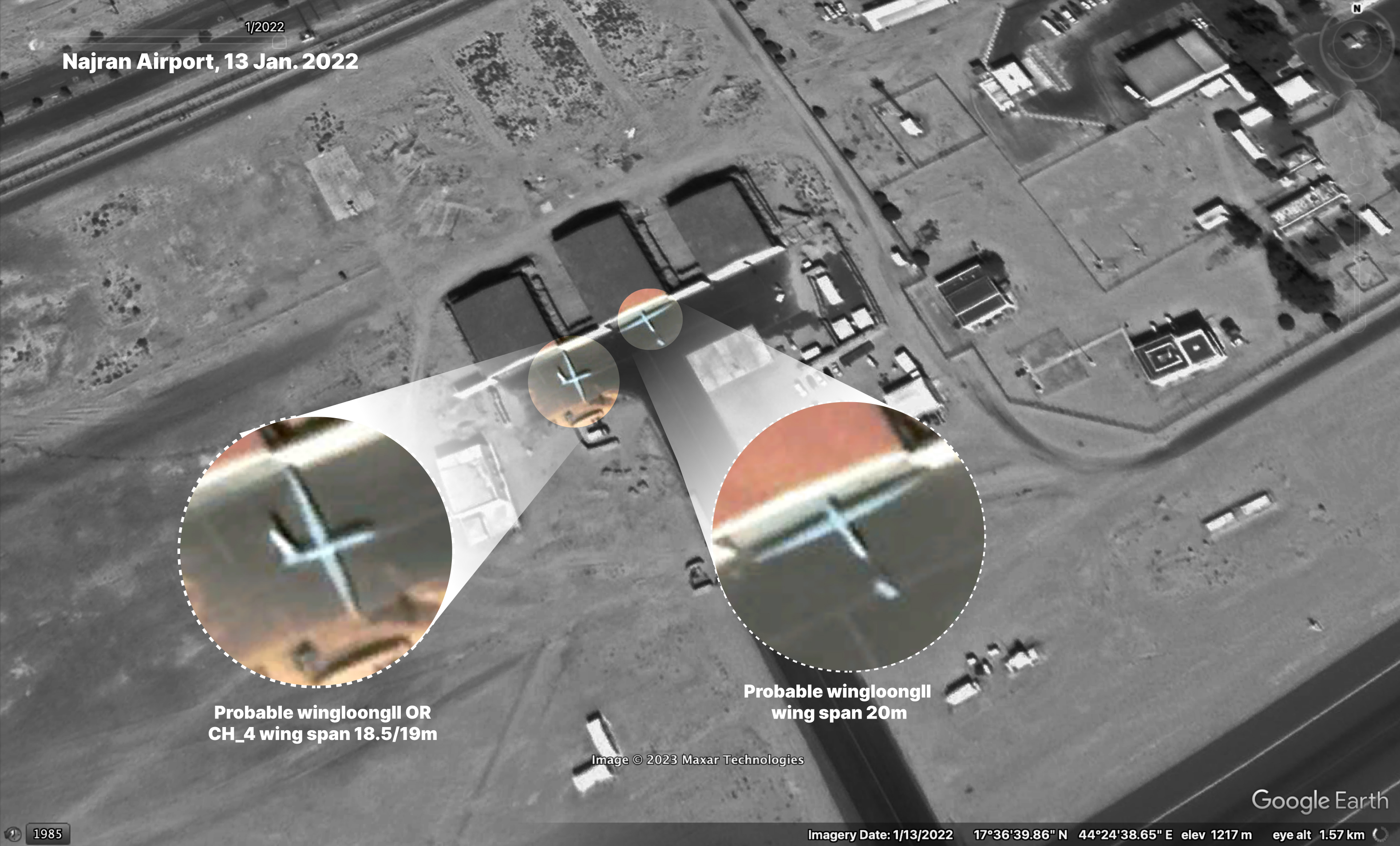
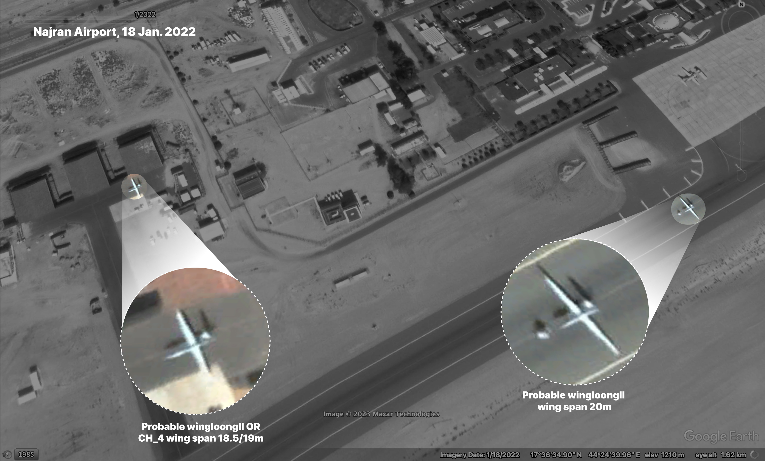
A screenshot from Google Earth of Najran Regional Airport showing what appear to be two UAVs. One of them is a Wing Loong II type, and another that may resemble the CH-4 type in January 2022.
Therefore, It appears that the crashed UAV that fell in the Al-Rowaishan-Sana’a roundabout might have been piloted by Saudi Arabia.
As Saudi Arabia is only known to operate the CH-4B variant, it appears likely that the crashed UAV is also of this variant. However, no weapons could be documented on wreckage, and the documented components of crashed UAV would be consistent with both A and B variants of the CH-4. It is worth noting, according to RUSI, Saudi Arabia generally relies on its large conventional air force to strike targets in Yemen, rarely using CH-4Bs for strike missions. Thus, it seems likely that the crashed UAV in Al-Rowaishan was not equipped with any weapons even though it was capable of carrying arms.
Summary
Based on the observable characteristics contained in available open source documentation, it appears that on 23 May 2022 between 20:50 and 20:54 local time, a Chinese-designed CH-4B UAV crashed into a street crowded with civilians near Al-Rowaishan roundabout in Amanat Al-Asimah Governorate. As a result, three civilians were killed and three others were injured, including women and a young man of Syrian nationality. Circumstantial indicators, including the analysis of the crashed UAV’s internal components and known combatant parties, as well as satellite imagery, all indicate that this UAV has been reliably operated by the Saudi Air Force. Due to the lack of visible fire, blast, or fragmentation damage on the wreckage, it is likely that the UAV did not crash as a result of hostile action, but from technical defects or user error. This is also consistent with the CH-4’s operational history, as highlighted by several operating countries.
This investigation includes a valuable contribution from the Armament Research Services (ARES), an apolitical research organisation.